


Drone Services
As an engineering company expanding into drone services, we bring a unique perspective to the table. Our expertise ensures that drone data seamlessly integrates with project planning and execution, providing clients with comprehensive solutions that save time, reduce costs, and enhance project outcomes.
Highpoint Engineering offers a unique advantage by combining expertise in drone operations with our deep knowledge as engineers and land planners, allowing us to not only streamline the process of planning shot lists but also provide expert insight into analyzing and utilizing the data captured to better serve your project needs.
Enhanced Project Monitoring: Drones provide real-time aerial views, allowing for precise monitoring of construction projects, environmental changes, or property developments, ensuring alignment with timelines and goals.
Improved Decision-Making: High-resolution imagery and data collection offer actionable insights for project adjustments, enhancing efficiency and reducing costs.
Regulatory Compliance Assistance: Drone inspections ensure adherence to environmental, safety, and zoning regulations, helping clients avoid fines and meet legal requirements.
Time and Cost Efficiency: Drones reduce the time needed for manual inspections and mapping, saving resources while delivering accurate and timely results.
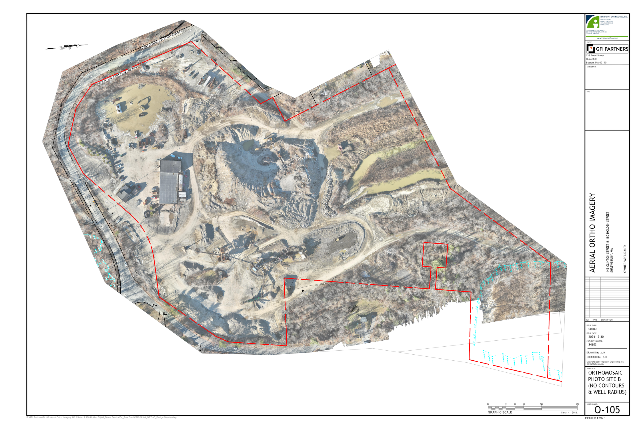
Comprehensive Site Analysis: From detailed 3D mapping to close-up views of structures, drones provide a holistic understanding of site conditions for construction, real estate, and environmental needs.
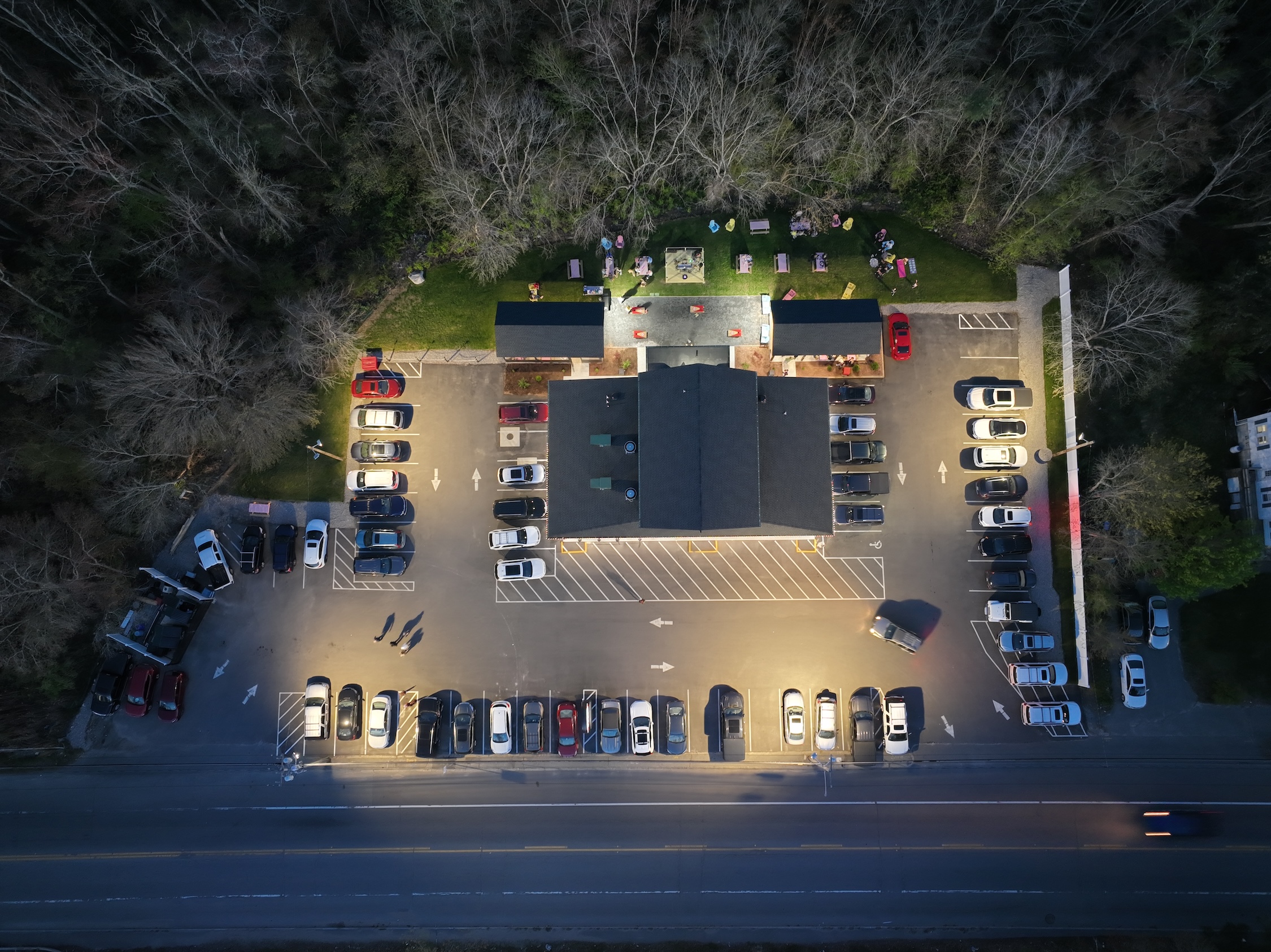
Superior Marketing Tools: Capture captivating visuals and videos to showcase properties or projects, standing out in competitive markets with professional-grade content.
Early Issue Detection: Drones identify potential problems such as structural defects, environmental impacts, or project deviations early, allowing for proactive solutions.
Safety Assurance: Drones minimize risks by performing inspections in hard-to-reach or hazardous areas, keeping personnel out of danger while ensuring thorough site evaluations.
Tailored Deliverables: Whether orthophotos, 3D models, or interactive maps, drone services provide customizable outputs that meet specific client needs.
Sustainability Support: Aerial monitoring aids in conservation efforts by tracking environmental changes, wildlife habitats, and landscape impacts, contributing to sustainability goals.

Why Choose Highpoint for Drone Services?
Industry Expertise: With decades of experience in civil engineering, land planning, and permitting, Highpoint integrates cutting-edge drone technology with a deep understanding of industry standards and project requirements.
Certified Professionals: Our FAA-certified Part 107 drone pilots ensure every flight complies with regulations, delivering safe, reliable, and high-quality results.
Seamless Integration: Unlike standalone drone companies, Highpoint combines drone services with our in-house engineering and consulting expertise, offering a one-stop solution for your project needs.
Proven Track Record: From construction inspections to real estate marketing and environmental monitoring, we have consistently delivered superior results for a wide range of clients.
Customizable Deliverables: Whether you need high-resolution imagery, 3D models, or compliance reports, we tailor our services to meet your specific objectives and requirements.
Commitment to Innovation: By leveraging the latest drone technology and software, we stay ahead of industry trends to provide faster, more accurate, and cost-effective solutions.
Client-Centric Approach: At Highpoint, your success is our priority. We work closely with you to ensure that our drone services align with your goals and deliver actionable insights.
Sustainability Focus: Our drone services prioritize environmental stewardship, helping clients achieve sustainability goals while maintaining regulatory compliance.
Cost-Effective Solutions: By utilizing existing infrastructure and advanced tools, we offer competitively priced services without compromising on quality or reliability.
Service Categories
Construction Monitoring and Inspections
- Track project progress with high-resolution aerial imagery and 3D site models.
- Identify potential issues early to avoid costly delays.
- Generate detailed construction inspection reports for stakeholders.
Environmental Monitoring
- Conduct aerial surveys to assess environmental impacts and changes.
- Monitor wildlife habitats, biodiversity, and ecosystem health.
- Support conservation efforts and compliance with environmental regulations.
Real Estate Marketing
- Showcase properties with stunning aerial photography and videos.
- Create immersive virtual tours to attract buyers and investors.
- Highlight neighborhood and location features to boost property appeal.
Permitting and Engineering Support
- Provide real-time aerial data for permitting applications and town meetings.
- Assist in design updates with accurate site visuals.
- Enhance decision-making with current, comprehensive site imagery.
Interested in Aerial Drone Services for Your Project?
Highpoint combines FAA-certified drone operations with engineering and land planning expertise, delivering aerial data that supports construction monitoring, permitting, environmental assessment, and real estate marketing.
Connect with Highpoint to discuss your project’s aerial imaging and data needs.